Key information
Publication type: The London Plan
Publication status: Adopted
Publication date:
Contents
11 sections
The Key Diagram
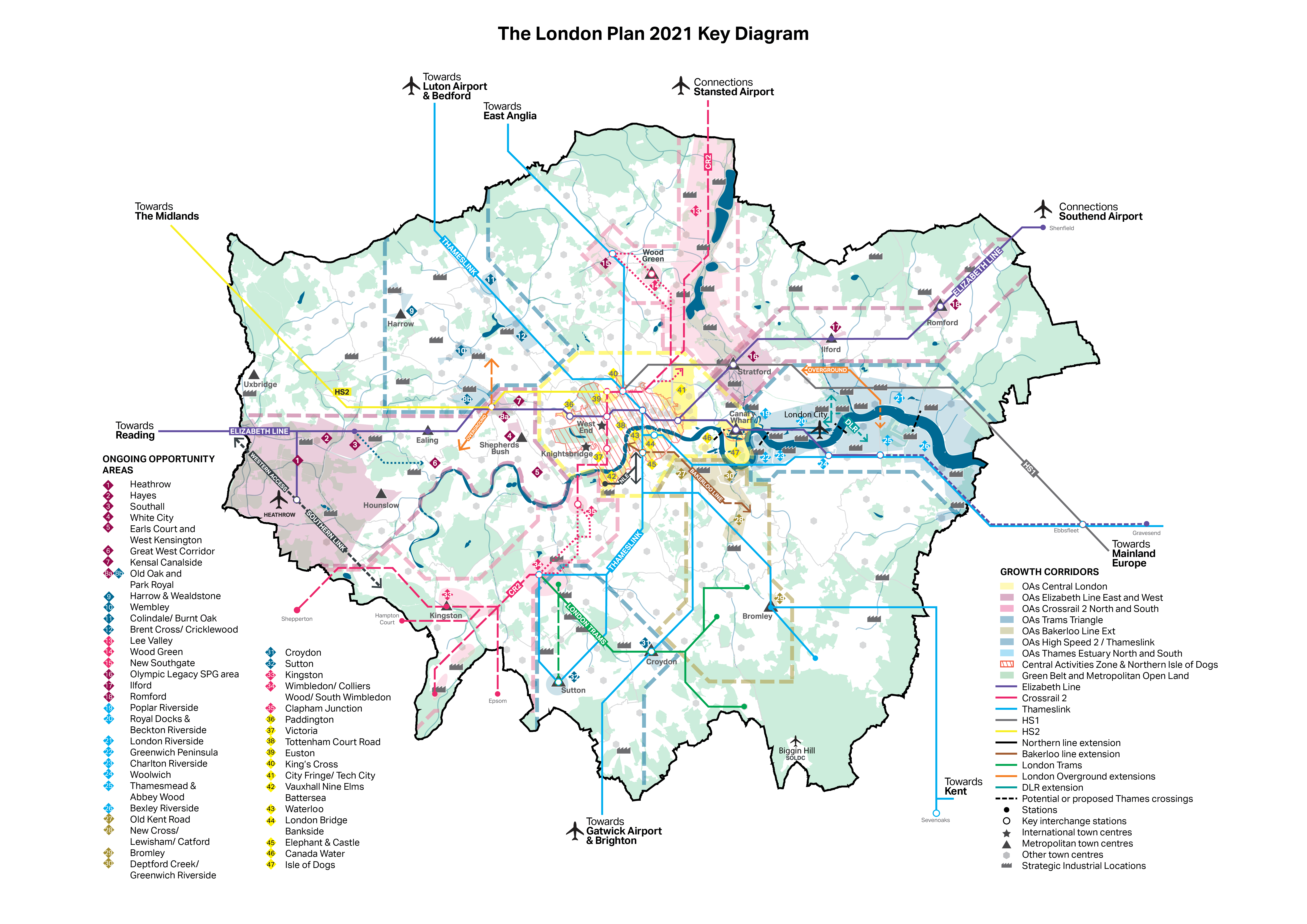
2.0.1 This chapter gives a strategic framework for those parts of London that will see significant development over the lifetime of the Plan, and addresses how change will be managed for London’s most sensitive and complex places. The Key Diagram (Figure 2.1) presents the spatial vision set out in this chapter, covering London’s growth corridors, Opportunity Areas, town centres, and Green Belt and Metropolitan Open Land.
2.0.2 London’s green and open spaces are a vital part of the capital. Its parks, rivers and green open spaces are some of the places that people most cherish and they bring the benefits of the natural environment within reach of Londoners. London’s Green Belt and Metropolitan Open Land designations (see Chapter 8) serve to protect these strategically-important open spaces, prevent urban sprawl and focus investment and development on previously developed land.
2.0.3 If London is to meet the challenges of the future, all parts of London will need to embrace and manage change. Not all change will be transformative – in many places, change will occur incrementally. This is especially the case in outer London, where the suburban pattern of development has significant potential for appropriate intensification over time, particularly for additional housing.
2.0.4 The areas that will see the most significant change are identified as Opportunity Areas. Many of these Opportunity Areas are already seeing significant development, and they all have the potential to deliver a substantial amount of the new homes and jobs that London needs. The London Plan has a clear focus on delivery – something that will require all stakeholders to work together to unlock sites and drive the right sort of development. Infrastructure is key to this delivery and will require major investment in transport, with Opportunity Areas clustered into growth corridors; and proper planning of utilities and communications capacity and the social infrastructure that supports the day-to-day lives of Londoners, well in advance of new development. Opportunity Area Planning Frameworks and Local Plans should have clear strategies for their delivery.
2.0.5 London’s influence and economy continue beyond the M25. Many of London’s growth corridors have links beyond London’s boundaries. Collaboration with Wider South East partners outside London will help to secure mutual benefits.
2.0.6 London’s Central Activities Zone (CAZ) and town centres are the primary locations for commercial activity in the capital. These are complex parts of London, with a wide mix of uses and unique local character. The CAZ and the town centre network have a crucial role to play in supporting London’s growth, and the London Plan sets out how this growth should be managed and planned for. Many town centres and the surrounding areas have potential to accommodate significant quantities of new housing, making the most of walking, cycling and public transport connectivity and complementing their commercial role.
2.0.7 Growth and change have not always benefited Londoners equally. In some cases, the wrong sort of growth has led to established communities finding themselves priced out of the area they call home. Some parts of the city have not benefited from the advantages the growth of London provides, with too many areas in London still experiencing deprivation despite the wider success of the capital. To address this, it is important that there is a strong focus on sustainable and inclusive regeneration in these areas, with boroughs, the Mayor and other partners working closely with the local community to bring about the right sort of change and investment. Where significant development is planned in these areas, it is crucial that it benefits local communities, provides employment and genuinely affordable housing, and is properly integrated into the area.
Policy SD1 Opportunity Areas
Growth Corridors and Opportunity Areas
2.1.1 Opportunity Areas are identified as significant locations with development capacity to accommodate new housing, commercial development and infrastructure (of all types), linked to existing or potential improvements in public transport connectivity and capacity. Opportunity Areas typically contain capacity for at least 5,000 net additional jobs or 2,500 net additional homes or a combination of the two. When developing policies for Development Plans, allocations and frameworks, boroughs should use the indicative capacity figures as a starting point, to be tested through the assessment process.
2.1.2 Many Opportunity Areas overlap with Strategic Areas for Regeneration, and have the potential to promote inclusive growth that increases opportunity for all Londoners.
2.1.3 The Mayor will provide the support and leadership to ensure Opportunity Areas deliver their growth potential for Londoners. He will promote and champion the areas as key locations for investment, and will intervene where required so that an ambitious, imaginative and inclusive approach is taken to accelerate and realise their growth and development. This approach should include understanding the existing character and context of an area, in accordance with Policy D1 London’s form, character and capacity for growth.
2.1.4 Opportunity Area Planning Frameworks (OAPFs) can represent the first stage in a plan-led approach to providing significant quantities of additional jobs and homes, improvements to transport and other infrastructure, and better access to local services. The Mayor recognises that there are different models for taking these forward depending on the circumstances and development needs of each Opportunity Area, and for translating these frameworks into policy in Development Plan Documents and Supplementary Planning Documents. Whatever model is used, frameworks must be prepared in a collaborative way with local communities and stakeholders.
Figure 2.2 - OAPF process diagram

2.1.5 The timescales in this diagram are indicative and based on the information available at the time it was compiled. While it may take some of the ‘nascent’ or ‘ready to grow’ Opportunity Areas 10-15 years to fully mature, there will be potential for new homes and jobs to be delivered in earlier phases. This will vary by area according to the scale and complexity of infrastructure and delivery issues. The categories will be kept under review as frameworks are produced and/or transport and other infrastructure delivered.
2.1.6 A crucial part of London’s future success will be improving access within and into the capital. The major transport infrastructure that facilitates this acts as a vital catalyst, unlocking new areas for development, enabling the delivery of additional homes and jobs, facilitating higher densities, using the Healthy Streets Approach to create vibrant neighbourhoods that are appealing places to walk, cycle and spend time, and providing local people with access to the facilities and services that they need.
2.1.7 Through the Mayor’s Transport Strategy, the London Plan and other strategies, the Mayor has identified Opportunity Areas (OAs) set out in Figure 2.4 to Figure 2.12. The growth corridors described below demonstrate the linkages between the OAs highlighting that they should not be planned in isolation. In order to meet London’s needs and ensure sustainable development, all stakeholders should seek to proactively promote and enable growth in these areas in line with the policies in this Plan. The Mayor will, and boroughs and other stakeholders should, develop effective cross-boundary working arrangements in order to unlock the full potential of the growth corridors within London.
2.1.8 In order to make the best use of land, enable the development of brownfield sites, and contribute to creating a healthy city it is important that development proposals appropriately deal with contamination so land can be safely used. Strategic opportunities should be explored for addressing land contamination, particularly where there are cross boundary issues. A joined-up approach to remediation can enable the costs and benefits of this to be shared. The development of Opportunity Area Planning Frameworks will be a key means of achieving this.
2.1.9 The key growth corridors within London are set out below. Policy SD2 Collaboration in the Wider South East and Figure 2.15 include Strategic Infrastructure Priorities that link into the wider city region. The Mayor will work with authorities outside London on the cross-boundary implications of Opportunity Areas.
Supporting London’s growth
2.1.10 The Mayor will put in place resources and support – such as his Good Growth Fund – to ensure that the potential of London’s growth corridors and Opportunity Areas is maximised. The Mayor’s London Housing Strategy and Transport Strategy set out his policies to achieve this.
2.1.11 The London Housing Strategy sets out four principal approaches:
- Land assembly, where the Mayor will both directly assemble land for development and support boroughs, Housing Associations and other homebuilders to do so. This may be through direct investment or through supporting compulsory purchase of appropriate land. He will also focus resources on areas where land suitable for development is not coming forward.
- Investing in housing and infrastructure, where the Mayor will put in place funding mechanisms to unlock development. This could include working with Transport for London to ensure transport improvements lead to increased delivery of homes and jobs, and will build on the current Housing Zones programme.
- Diversifying the tenure mix of new homes, where the Mayor will provide funding to increase the number of new and affordable homes. This will include funding to support more innovative forms of housing delivery.
- Increasing capacity, where the Mayor will lead an improvement in the skills, capacity and building methods of the construction industry.
2.1.12 The Mayor’s Transport Strategy seeks to ensure that public transport and walking and cycling provision are at the heart of planning for Opportunity Areas. It sets out that the Mayor will support growth in Opportunity Areas through transport investment and planning, and commits to setting ambitious mode share targets.
2.1.13 In the Mayor’s Transport Strategy a number of priority infrastructure schemes have been identified that would bring significant regeneration benefits, including the potential to unlock substantial homes and jobs growth in specific Opportunity Areas. The development value in these areas can, in some cases, also contribute to the funding of schemes. In order to support these priorities, this Plan sets out further guidance on the Opportunity Areas below, grouped by growth corridor. The general location of each one is set out in a series of diagrams. These also show indicative guideline figures for housing and employment capacity in each area. The capacity of many of these areas for new homes and jobs will increase significantly as a result of major public transport schemes and the improvements to capacity and connectivity they provide. Homes and jobs figures will be reviewed as infrastructure schemes are confirmed and delivery timescales become clearer so that they maximise the opportunities for additional growth. Where development proposals are emerging and transport investment is not yet fully secured, delivery of the long-term capacity for homes and jobs will need to be phased in a way that maximises the benefits of major infrastructure and services investment whilst avoiding any unacceptable effects on existing infrastructure before schemes are delivered.
Table 2.1 - Opportunity Area Indicative capacity for new homes and jobs
* Homes figure based on 2017 SHLAA capacity from 2019 – 2041. If no SHLAA data available, most recent Development Plan or OA threshold figure used.
^ Jobs figure based on the London Employment Sites Database for the period 2016 to 2041. Where no figure available, most recent Development Plan used.
Figure 2.3 - Key to symbols on the growth area figures

Bakerloo Line Extension
2.1.14 The Mayor is proposing to extend the Bakerloo line from Elephant & Castle to Lewisham and beyond, serving Old Kent Road and New Cross Gate. The extension will improve connectivity, increase the capacity and resilience of the transport network and reduce journey times between key destinations. This will help London to grow by supporting new homes and jobs.
2.1.15 The Mayor has concluded that an extension to Lewisham via Old Kent Road and New Cross Gate is the best option for an initial Bakerloo line extension. There is also the potential for future extensions of the scheme beyond Lewisham. Planning frameworks should identify the development opportunities which are made possible as a result of the Bakerloo line extension, as well as how this would be phased to reflect the connectivity and capacity benefits it unlocks.
Figure 2.4 - Bakerloo Line Extension

Old Kent Road OA
2.1.16 Southwark is preparing an Area Action Plan (AAP) which will set out how the BLE will enable significant residential and employment growth. The Old Kent Road OA contains the last remaining significant areas of Strategic Industrial Locations that lie in close proximity to the CAZ and the only SILs within Southwark. The AAP should set out how industrial land can be intensified and provide space for businesses that need to relocate from any SIL identified for release. Areas that are released from SIL should seek to co-locate housing with industrial uses, or a wider range of commercial uses within designated town centres. Workspace for the existing creative industries should also be protected and supported.
2.1.17 Any new town centres should be designated close to the potential new Tube stations and should be of an appropriate scale, taking into account capacity and the impact on nearby centres. Burgess Park is a significant open space and a substantial part of the identity of the Old Kent Road. The need for the additional public open spaces the area will require as it evolves, and its broad location and scale, should be set out as part of the AAP.
New Cross/Lewisham/Catford OA
2.1.18 There remain significant opportunities for redevelopment especially around stations, which should complement the existing education, leisure, employment and retail offer in New Cross as well as provide additional housing alongside public realm and highways improvements. The proposal for a Bakerloo line extension station at New Cross Gate will enable delivery of these developments and improvements. The area has an established commercial centre capable of supporting commercial expansion and diversification, building on the existing assets such as Goldsmiths College, University of London areas of artistic and cultural character. Development should improve north-south connections and pedestrian and cycling movement across and along the traffic-dominated New Cross Road (A2) as well as connectivity between New Cross Gate and surrounding communities.
2.1.19 Lewisham will grow in function and population and has potential to become a town centre of Metropolitan importance. The town centre retail and commercial functions are being intensified, rationalisation of the public highway will create improved pedestrian routes, and significant residential developments surrounding the town centre are underway, including Lewisham Gateway. The potential for further growth at Lewisham will be supported by the arrival of the Bakerloo line at Lewisham Interchange. This will bring enhanced access to central London and encourage the delivery of employment, leisure, service and community uses that serve the local and sub-regional population. Public realm and environmental enhancements of the town centre and surrounding employment, mixed-use and residential re-developments will continue to be delivered and will assist the continued transformation of Lewisham into a high performing and vibrant retail hub with excellent leisure services.
2.1.20 Catford has potential for significant urban renewal. Large-scale redevelopment of five key sites – Catford Shopping Centre and Milford Towers, Laurence House, Town Hall and Civic Centre, Plassy Island, Wickes and Halfords – will help to transform the town centre by 2026. There is scope to restore the fractured town centre and to re-invigorate it by boosting the existing civic and cultural facilities and by providing an improved retail, office and leisure offer. To support the area, approximately 2,700 new homes can be accommodated in the heart of the town centre. The realignment of the A205 will assist in the transformation of the town centre. In the longer term, the potential routing of the Bakerloo line extension Phase 2 through Catford could unlock further development potential elsewhere in the town centre and beyond.
Crossrail 2
2.1.21 Crossrail 2 is a proposed new railway serving London and the Wider South East. To the south, it will connect the South West Mainline via new tunnels from Wimbledon, through central London to New Southgate and Tottenham Hale where it will connect with the West Anglia Mainline. As well as reducing journey times, increasing capacity, and reducing crowding across London’s transport network, it will transform connectivity to and from key growth areas across London and beyond. It will support up to 200,000 new homes and 200,000 new jobs, connecting some of London’s major growth locations with potential strategic growth locations outside London.
2.1.22 It is anticipated that Crossrail 2 will be operational in the 2030s. The Mayor has submitted the Strategic Outline Business Case for the scheme to the Government. Crossrail 2 and associated investment will have a significant impact on the locations it serves and the wider catchments of stations and linked services. This regeneration impact will help support the delivery of housing, mixed-use and commercial development across the corridor and the opportunity areas located within it, as described below. Planning frameworks for all areas affected by Crossrail 2 should respond to the significant development capacity unlocked by Crossrail 2. Frameworks should outline how this additional development capacity would be phased to reflect the transport connectivity and capacity improvements that Crossrail 2 enables.
2.1.23 Beyond London’s boundaries Crossrail 2 is part of two Strategic infrastructure Priorities (see Figure 2.15 (4) and (10)).
Crossrail 2 South
Figure 2.5 - South West London/Crossrail 2 South

Kingston OA
2.1.24 The Royal Borough of Kingston upon Thames’s network of town centres with their good levels of public transport accessibility have been identified as areas capable of accommodating development and intensification to provide leisure, cultural and night-time activity, commercial and retail uses, as well as high density housing. A Direction of Travel document was adopted in 2016 to guide planning policies in these areas. In particular it identified four areas where there is scope for significant change:
- Kingston Town Centre
- Norbiton, London Road and Cambridge Road Estate
- New Malden
- Tolworth
2.1.25 These areas are capable of supporting some development in the short and medium term. However, once Crossrail 2 is operational, the borough will benefit from more Crossrail 2 stations than any other and the arrival of the new, higher frequency, higher capacity service will enable significant additional growth opportunities in these areas. It will improve Kingston’s attractiveness as an office location and therefore support additional commercial growth in the town centre, building on links with Kingston University and Kingston College. The Local Plan and/or Planning Framework should set out how Crossrail 2 will support and deliver further growth and intensification in these areas. It should also explore how the use of industrial land can be intensified to make more efficient use of land. Kingston town centre, with its ancient market is rich in heritage and forms an important part of the setting of Hampton Court Palace, its gardens, the Thames and surrounding Royal Parks.
2.1.26 In the longer term, and following the opening of Crossrail 2 in the 2030s, there may be potential for selective redevelopment in the following areas:
- Berrylands Station and Hogsmill Valley
- Chessington
Wimbledon/South Wimbledon/Colliers Wood OA
2.1.27 The step change in transport capacity and connectivity offered by Crossrail 2 will transform Wimbledon into a major transport hub with opportunities for interchange with National Rail, trams and the Underground. The redevelopment required to deliver the Crossrail 2 tunnel offers the opportunity to plan for significant growth and intensification, with residential and commercial development. Crossrail 2 will strengthen Wimbledon’s role as a Major town centre, and as a location with potential for speculative office development, helping to meet the Mayor’s ambition to promote growth in employment in outer London centres. The planning framework should also explore and quantify the opportunities for development associated with Crossrail 2 in the surrounding area, and how the use of industrial land can be retained and intensified to make more efficient use of land. The planning framework should also explore the potential for development at Morden Town Centre.
Clapham Junction OA
2.1.28 Clapham Junction is Europe’s busiest rail interchange station, serving key commuter routes from West London and Southern England, and is identified as one of London’s four strategic interchanges expected to accommodate rising levels of demand. However, the station is already operating at capacity in terms of rail services and passenger numbers and suffers from over-crowding at peak times. Reconfiguration of the existing rail infrastructure and the station is needed to increase capacity and substantially improve passengers’ public transport experience. The proposal for a Crossrail 2 station represents a unique opportunity to make more efficient use of land surrounding the station for residential and commercial development, including new offices as part of the designated Major town centre. The Planning Framework will need to fully explore and evaluate options for comprehensive over-station development, which would be reliant on a reconfiguration of the station layout. This will include the consideration of complex technical issues related to the operation of the railway and the integration with other transport infrastructure and services, including Crossrail 2. Careful consideration will need to be given to the urban design and place-making of the development and its integration into the existing streets and functions surrounding the station. It will be important to consider integration of any development with surrounding residential areas, and the Housing Zone.
Crossrail 2 North
Figure 2.6 - Lee Valley, New Southgate and Wood Green/Crossrail 2 North

Lee Valley OA
2.1.29 The Lee Valley occupies a strategic position in the London-Stansted-Cambridge-Peterborough growth corridor and provides a range of development opportunities for higher density development. These opportunities include the growth at Tottenham Hale, Blackhorse Lane, Meridian Water, Ponders End, Lea Bridge and Leyton, Stamford Hill, Clapton and the Lea Bridge roundabout, as well as other accessible sites within and on the edges of town centres, especially in the A10 and A1010 corridors. Crossrail 2 will transform transport connectivity and capacity in the Upper Lee Valley and is vital to support the full, long-term potential development capacity.
2.1.30 In the shorter term, a four-trains-per-hour service on the West Anglia Main Line at Meridian Water and Northumberland Park will support development and regeneration. Beyond this, four tracking of the line between Coppermill Junction and Broxbourne can unlock development capacity along the route.
2.1.31 Development in the Opportunity Area should fully capture the benefits of these significant transport interventions and provide the stimulus for regeneration, broadening employment opportunities for existing communities including those in Edmonton, the Tottenham corridor from Stoke Newington to Northumberland Park, and around Blackhorse Lane and Walthamstow.
2.1.32 The Lee Valley is ideally located for freight and logistics, straddling both the North Circular and M25, and providing a link to Stansted, Cambridge and beyond in the north, and to Central London in the south. It will continue to play an important strategic role in providing industrial and logistics functions to support the wider London economy and contribute to local employment.
2.1.33 The Planning Framework should quantify the full development potential of the area as a result of Crossrail 2. It should ensure that industrial, logistics and commercial uses continue to form part of the overall mix of uses in the area, and that opportunities for intensification of industrial land and co-location of industrial and residential uses are fully explored. Tottenham and Walthamstow contain clusters of creative industries which should be protected and supported. The Planning Framework should also protect and improve sustainable access to the Lee Valley Regional Park and reservoirs, and ensure links through to Hackney Wick and the Lower Lea Valley. Planning frameworks should include an assessment of any effects on the Epping Forest Special Area of Conservation and appropriate mitigation strategies.
Wood Green/Haringey Heartlands OA
2.1.34 A range of development opportunities will be delivered with the aim of creating a revitalised employment-led Metropolitan town centre. The area benefits from excellent, and – subject to confirmation of Crossrail 2 coming to the area – improving public transport connections and capacity, which make Wood Green an ideal location for growth in employment and service provision to serve the central portion of north London. Key sites with development potential include the Clarendon Road gas works and adjacent Wood Green Cultural Quarter, as well as significant publicly-owned land parcels around the High Road, and Wood Green Shopping City. Mixed-use regeneration of these sites will deliver an expanded employment, retail and leisure offer, as well as new homes.
2.1.35 The Planning Framework should quantify the scale of development associated with Crossrail 2, promote the opportunity to build on the area’s industrial heritage through new and refurbished workspace in the west of the area, and support retail provision. It should also set out how site assembly and provision of better links with the town centre and surrounding areas including Alexandra Palace Park hold the key to comprehensive development.
New Southgate OA
2.1.36 The arrival of Crossrail 2 at New Southgate can significantly enhance accessibility and connectivity to support regeneration in the wider area. The Planning Framework should review the development capacity of this area in the light of Crossrail 2. Initial estimates indicate that this could be significantly greater than the current estimated capacity for new homes and jobs.
2.1.37 The benefits of the existing good public transport accessibility to the north and east are hampered by the severance effect of major transport corridors through the area. The area to the west of the East Coast Main Line and to the south of the A406 North Circular suffer from poor quality environment and lack of proper connections to the stations and the wider area. The high traffic flows on the North Circular Road have a dominant and adverse impact on local residents and businesses by way of congestion, noise, air pollution and poor public realm along the corridor.
2.1.38 There is potential to deck over a small section of the North Circular immediately to the south of New Southgate Station and/or tunnel a section of the North Circular between New Southgate and Green Lanes. The Planning Framework should also consider the benefits and viability of these options including their potential to unlock the delivery of new homes and jobs as well as complement other transport initiatives in the area and the wider environmental, health and public realm benefits.
Thames Estuary North and South
2.1.39 The corridor either side of the Thames Estuary represents the largest concentration of Opportunity Areas in the city. It continues to be a priority for regeneration and economic development, with potential for over 250,000 new homes and 200,000 new jobs.
2.1.40 Development in a number of the Opportunity Areas in this corridor is coming forward at a fast pace, with significant development in the Isle of Dogs, Greenwich Peninsula and Woolwich. Others are about to benefit from new transport infrastructure, such as Barking Riverside with the extension of the Overground, and Thamesmead/Abbey Wood with the Elizabeth line. Others are dependent on the development of infrastructure schemes in order to unlock their full potential, such as Bexley Riverside.
2.1.41 The Mayor has set out his vision to transform the Thames Estuary into a hub for large-scale state-of-the-art production facilities with an initial focus on creative and cultural industries. In their Local Plans, boroughs should consider how to encourage and support large-scale production facilities to create jobs, enhance the skills of local people and drive growth to benefit the area.
2.1.42 The Mayor will continue to work with Thames Estuary partners to support and promote investment in the area, both within and outside London.
2.1.43 The lack of river crossings in the area is holding back growth and development, and the Mayor has prioritised or is exploring a number of schemes which will help to unlock and/or connect growth areas:
- Silvertown Tunnel
- a new river crossing linking Rotherhithe and Canary Wharf
- an extension of the DLR across the river from Gallions Reach to Thamesmead and beyond
- Barking Riverside to Abbey Wood London Overground crossing.
2.1.44 The Mayor will also support the Thames Gateway Kent Strategic Corridor by assisting boroughs in seeking a Government-led project to extend the Elizabeth line through Bexley to north Kent.
2.1.45 This corridor links beyond London’s boundaries into two Strategic Infrastructure Priorities (see Figure 2.15 (6) and (7)).
Figure 2.7 - Thames Estuary

Poplar Riverside OA
2.1.46 Poplar Riverside lies south of the Olympic Legacy Supplementary Planning Guidance area, and between the Isle of Dogs & South Poplar and Royal Docks Opportunity Areas. The new OA designation incorporates parts of the Lower Lee Valley area that are outside the Olympic SPG and LLDC areas. It contains the Poplar Riverside Housing Zone on the Tower Hamlets side of the River Lea. This has the potential for 9,000 new homes and improved connectivity in a part of the borough with significant infrastructure challenges.
2.1.47 The OA crosses the boundary of the River Lea into the London Borough of Newham, where there are opportunities to provide both intensified employment uses and residential development. Cross-boundary working is required to maximise investment of the Housing Zone funding and the development potential of upgrades to Canning Town station and the arrival of the Elizabeth line at Custom House. Significant local transport improvements are needed to allow better pedestrian and cycle accessibility over the River Lea via footbridges and to remove the severance effect of major infrastructure such as DLR lines and the A12 at Gillender Street.
Royal Docks OA
2.1.48 This area sits at the heart of the Thames Gateway presenting one of the largest regeneration opportunities in London. It benefits from the presence of important existing industry and attractors such as ExCEL and City Airport, and will soon see an Elizabeth line station at Custom House. The Royal Docks will become a vibrant new London quarter, creating a world-class business, industrial, cultural and residential district. Key to delivering this will be ensuring high-quality development with new infrastructure, homes and workspaces, including creative cultural, evening and night-time economy uses, in recognition of the Mayor’s aspiration for a Thames Estuary Production Corridor for culture and creative industries.
2.1.49 Significant housing-led mixed-use developments have already been completed or are underway, such as Royal Wharf, Barrier Park East, Gallions Quarter and Great Eastern Quays. The consented major new mixed-use schemes at Advanced Business Parks (London) and Silvertown Quay will contribute to the transformation of the area.
2.1.50 The Mayor has established the Royal Docks Delivery Team to guide development of the Enterprise Zone and surrounding Opportunity Area. The area contains a number of safeguarded wharves, and there is a continuing need to retain wharf capacity. The Planning Framework should set out how wharves could be consolidated to deliver more effective and efficient industrial uses alongside residential/mixed use. The area has significant areas of SIL and recent evidence confirms that there is a continued demand for industrial space in the east of London. The Planning Framework should ensure industrial capacity is managed in ways that reduce overall vacancy rates and support the intensification of industrial, logistics and commercial uses so that they continue to form part of the overall mix of uses in the area.
2.1.51 The Planning Framework should also set out how to manage the opportunities for mixed-use development at Canning Town/West Ham, and Thameside West where there is or will be excellent public transport connectivity. Silo D is a heritage asset at risk which provides opportunities for heritage and cultural-led regeneration. At Beckton Riverside de-commissioning of the gasholders together with a new DLR station provides an opportunity to deliver waterside residential-led mixed-use development. New residential development here will support the evolution of Gallions Shopping Centre, which has the potential to become a designated town centre. The Planning Framework should set out how new development can accommodate an extension of the DLR across the river to Thamesmead.
2.1.52 The DLR provides the key transport links through the area, and Beckton Depot will be retained and expanded to support the upgrade of the DLR fleet.
Thamesmead and Abbey Wood OA
2.1.53 Housing Zone status and investment by Peabody in estate renewal in the area will improve the quality of the environment and bring new housing opportunities. To deliver wider regeneration benefits to Thamesmead, other interventions to support the growth of the Opportunity Area are needed. These include: the redevelopment and intensification of employment sites to enable a range of new activities and workspaces to be created in parallel with new housing development; a review of open space provision in the area to create better quality, publicly accessible open spaces; the creation of a new local centre around Abbey Wood station, the revitalisation of Thamesmead town centre and Plumstead High Street; and improved local transit connections.
2.1.54 Alongside the opening of the Elizabeth line, major investments in transport infrastructure such as the proposed DLR extension from Gallions Reach are also needed to support high density development and provide access to areas of significant employment growth, such as the Royal Docks, for existing and new residents of Thamesmead. To accommodate the expected growth in the area, utility infrastructure – in particular water and electricity supply, broadband and a local heat network – should be upgraded and/or planned for accordingly. In view of the low-lying nature of parts of the area, particular attention should also be given to flood risk management.
Bexley Riverside OA
2.1.55 The Bexley Riverside OA stretches along the south side of the Thames and includes the areas of Belvedere, Erith, Slade Green and Crayford. Future improvements to accessibility through better services on the existing transport network, and the extension of the Elizabeth line to Slade Green and beyond, offer the opportunity for significant redevelopment around the stations. The Mayor will support the borough and the adjoining Kent authorities in seeking a Government-led extension of the Elizabeth line. In the interim, within London, the Planning Framework should explore the level of growth that could be supported through significantly enhanced bus services and priority measures.
2.1.56 Industrial and logistics uses will continue to play a significant role in the area. Belvedere is recognised as having potential as a future District centre.
High Speed 2 / Thameslink
2.1.57 At the heart of this area, Old Oak is set to be transformed by the late 2020’s with the opening of Old Oak Common Station, which will connect the Elizabeth line and National Rail services to the newly built High Speed 2 line. The creation of this new station will dramatically improve public transport in the immediate area, and across London. The boroughs are examining the feasibility of a new rail link from Brent Cross to Hounslow, via Old Oak. This West London Orbital Line could unlock significant new growth in the area.
2.1.58 This corridor links beyond London’s boundaries into a Strategic Infrastructure Priority (see Figure 2.15 (12)).
Figure 2.8 - High Speed 2 / Thameslink

Old Oak / Park Royal
2.1.59 The Mayor has established the Old Oak and Park Royal Development Corporation (OPDC) to drive forward regeneration of this area. A Local Plan has been published which recognises the huge regeneration potential of the area and sets out a clear strategy for how redevelopment should help to optimise economic growth and regeneration potential, create a new town centre and bring tangible benefits for local communities and Londoners. Positive masterplanning will be used to create an attractive new town centre with distinctive character.
2.1.60 Old Oak Common station (connecting HS2, the Elizabeth line and National Rail) is set to open by the late 2020’s. There are significant opportunities to bring forward regeneration in advance of this date around the existing and potential new rail stations in the area. This includes North Acton on the Central line and Willesden Junction on the Bakerloo line and London Overground, as well as the potential new local stations at Hythe Road and Old Oak Common Lane on the Overground.
2.1.61 Park Royal is a strategically-important industrial estate for the functioning of London’s economy and should be protected, strengthened and intensified.
Elizabeth Line East
2.1.62 The Elizabeth line will transform connectivity along the route. It is already leading to increased development in central London and has the potential to bring forward growth and development from Stratford eastwards. This includes the area of the London Legacy Development Corporation, which continues to secure the legacy of the 2012 Olympic and Paralympic Games.
2.1.63 This corridor links beyond London’s boundaries into a Strategic Infrastructure Priority (see Figure 2.15 (5)).
Figure 2.9 - Elizabeth Line East

Heathrow/Elizabeth Line West
2.1.64 The area contains a range of opportunities to support London’s economic development and deliver new housing and environmental improvements. Policy T8 Aviation confirms that the Mayor will oppose any expansion of Heathrow Airport unless it can be shown that: no additional noise or air quality harm would result; the benefits of future regulatory and technology improvements would be fairly shared with affected communities; and that sufficient surface access capacity would be provided by the Government and/or the airport authority.
2.1.65 The Mayor will therefore review and clarify the area’s potential contribution to London’s growth when expansion proposals and their spatial and environmental implications are clearer. This will include reviewing the housing and jobs targets for opportunity areas and working with boroughs to support more detailed plans, such as through Opportunity Area Planning Frameworks or Local Plans.
2.1.66 As the implications of Heathrow also go beyond London’s boundaries, the Mayor will work with local authority partners beyond London’s boundaries on related challenges and opportunities, in line with Policy SD2 Collaboration in the Wider South East and Policy SD3 Growth locations in the Wider South East and beyond.
2.1.67 This corridor links beyond London’s boundaries into a Strategic Infrastructure Priority (see Figure 2.15 (11)).
Figure 2.10 - Elizabeth Line West

Great West Corridor
2.1.68 The Great West Corridor is one of London’s key approaches and presents unique opportunities for place-making. It inspired high-quality Art Deco architecture in the 1930s, creating a distinctive local character. The route is surrounded by some of London’s most significant historic landscapes including the River Thames, Syon Park, Gunnersbury Park, Osterley Park and The Royal Botanic Gadens Kew World Heritage Site. Masterplanning in the corridor should carefully consider these natural and historic assets, utilising the latest modelling techniques. The opportunities to integrate and draw inspiration from the area’s heritage should be fully explored.
Central London
2.1.69 Central London is a key driver for both London’s economy and the UK economy as a whole, comprising both the CAZ and Northern Isle of Dogs (see Policy SD4 The Central Activities Zone (CAZ) and Policy SD5 Offices, other strategic functions and residential development in the CAZ) and the closely related areas of Canada Water and City Fringe/Tech City. It contains a large number of OAs, many of which are maturing or underway and benefiting from successful development schemes that will be completed over the next few years.
Figure 2.11 - Central London

Euston
2.1.70 Euston is a major national and commuter rail terminal with good public transport links to the rest of the CAZ. The existing mainline station is outdated, the local environment has areas of poor quality, and the over-station airspace and adjacent areas are underused. There is significant potential for intensification and an opportunity to comprehensively transform Euston and the immediate area into a world-class transport interchange and new residential and business district. Scope exists to reconfigure Euston Square Gardens and the bus station to enhance this space and improve transport facilities and to also complement the expanding knowledge quarter. This should support the area’s strengths in the Life Sciences and Tech industries. The ‘Euston Area Plan’ produced by the GLA, working with Transport for London and Camden Council was adopted in 2015.
2.1.71 HS2 has now received Royal Assent and options for the potential redevelopment of the existing station have come forward in addition to proposals for a Crossrail 2 interchange. This could greatly assist in improving interchange capacity in the longer term. Working with the station operators, the GLA and Camden Council, the Department for Transport is seeking to pool the various land interests and secure a development partner to assist in delivering a comprehensive redevelopment at Euston. A planning brief for the area around Euston Station is currently being produced.
Trams Triangle/London-Gatwick-Brighton mainline
2.1.72 This area of South London contains the key town centres of Croydon, Sutton and Wimbledon, with important links to central London and Gatwick via the Brighton mainline and, in the future, Crossrail 2. The Tram has transformed travel opportunities in the area and provides the potential for further growth in homes and jobs. The proposal to extend the Tram to Sutton Town Centre, and potentially beyond to the proposed Cancer Hub, would improve public transport accessibility to the town centre and St. Helier Hospital, and support the delivery of at least 10,000 homes. TfL and the GLA are working with the boroughs to produce a robust business case and funding package, demonstrating how housing and employment growth can be unlocked.
2.1.73 This corridor links beyond London’s boundaries into a Strategic Infrastructure Priority (see Figure 2.15 (9)).
Figure 2.12 - Trams Triangle

Policy SD2 Collaboration in the Wider South East
2.2.1 London is not an island. There are 130 authorities in the WSE outside London. Though it is significantly larger than other centres in the Wider South East, London is part of an extensive and complex network of centres of different sizes and functions. Some are of considerable strategic importance in their own right and the focus of their own sub-regional networks of centres. The network as a whole, and the orbital and radial linkages, which hold it together, comprise the most productive region in the UK accounting for nearly half its output and making by far the biggest net contribution to the national exchequer.
2.2.2 The WSE is home to 24.2 million people (8.9 million in London), 10.0 million households (3.6 million in London) and 13.7 million jobs (5.7 million in London). It is projected to grow more rapidly by 2041 than other parts of the UK – in population terms by 21 per cent in London and 17 per cent in the WSE outside London. Household numbers are expected to increase by 32 per cent in London and 23 per cent elsewhere in the WSE.
2.2.3 Both London and the rest of the WSE benefit from this regional dynamism. The effects of London’s housing and labour markets and their related multiplier effects extend far beyond its administrative boundaries. 800,000 commuters travel into London each day (more than half of the workforce in some of the local authorities bordering London – see Figure 2.13) and make an important contribution to its economy as well as to the commuters’ own local economies when they return home. Figure 2.14 illustrate trends in migration flows into and out of London.
2.2.4 There are mutual benefits for authorities across the WSE in working together to tackle these regionally important matters. Historically, a formal regional structure was in place to coordinate approaches to them. A non-statutory strategic structure has now been put in its place to address them,[6] facilitated by South East England Councils, the East of England Local Government Association, London Councils and the Mayor.
2.2.5 The new structure provides the basis for coordinated approaches to Government on pan-regional, general issues referred to in Part E of the policy. Opportunities to collaborate should be considered where mutual benefits can be achieved. The scope of these opportunities may vary depending on circumstances including proximity to London. The promotion of good links to/from potential employment locations outside London by the Mayor to help realise corresponding employment opportunities within and outside London is an example of how mutual benefits can be achieved. The Golden Triangle (life science sector collaboration with Oxford and Cambridge) and the Thames Estuary Production Corridor (delivering large-scale cultural infrastructure) are good examples of collaboration that is already underway.
2.2.6 This non-statutory structure for collaboration that is in place complements the GLA Act requirement for the spatial development strategy to address matters of strategic importance to Greater London (GLA Act, VIII, S.334 (5)) and the Mayor’s statutory Duties to Inform and Consult (GLA Act, VIII, S.335 ‘with adjoining counties and districts’, S.339 ‘authorities outside London’, S.348 ‘authorities in the vicinity of London’).
2.2.7 Authorities outside London have a similar Duty to Co-operate (Localism Act 2011) with the Mayor on relevant matters of strategic importance as part of the process of preparing their Local Plans. In addition, Planning Practice Guidance[7] states that ‘cooperation between the Mayor, boroughs and local planning authorities bordering London will be vital to ensure that important strategic issues, such as housing delivery and economic growth, are planned effectively’. The Mayor will share his responses to Local Plans outside the capital with interested London boroughs.
2.2.8 The Mayor supports and encourages collaborative regional working through his planning activities. However, locally-specific cross-border matters between individual London boroughs and authorities beyond London should be addressed most effectively by the relevant local authorities on the basis of their Duties to Cooperate.
2.2.9 To inform local housing need assessments the GLA has prepared authoritative and consistent demographic projections across the whole of the UK, which take into account the significant short-term, cyclical changes in migration flows from London. Partners are also exploring the scope to collate other consistent regional datasets.
Figure 2.13 - Spatial Distribution of Commuting to London

Figure 2.14 - Average annual gross migration flows 2016 – 2041

Policy SD3 Growth locations in the Wider South East and beyond
2.3.1 This Plan aims to accommodate the majority of London’s growth within its boundaries without intruding on its Green Belt or other protected open spaces. As with any successful urban area, this does not mean that in- and out-migration will cease, but that as far as possible sufficient provision will be made to accommodate the projected growth within London.
2.3.2 To ensure a common understanding of growth projections across the wider region the GLA will provide regionally-consistent demographic data, which takes into account long-term trends, and the Mayor will refer to this data as part of his representations on emerging Local Plans.
2.3.3 The GLA’s new Strategic Housing Market Assessment shows that London has a need for approximately 66,000 additional homes a year. The Plan’s housing target of approximately 520,000 homes over ten years is based on the findings of the new Strategic Housing Land Availability Assessment and informed by the Examination in Public process.
2.3.4 Although this Plan is seeking to accommodate the majority of London’s future growth within its boundary, given the pressure for growth in both London and the WSE, the barriers to housing delivery that need to be overcome to avoid a further increase of the backlog, and potential changes to projections over time, it is prudent to also plan for longer-term contingencies. Therefore, the Mayor is interested in working with willing partners beyond London to explore if there is potential to accommodate more growth in sustainable locations outside the capital.
2.3.5 This partnership work could help deliver more homes, address housing affordability and improve economic opportunities outside London. The focus is on locations that are (or are planned to be) well-connected by public transport and where development can help meet local growth aspirations as well as wider requirements. Recognising that investment in public transport can often bring significant benefits to wider areas, such partnerships could focus on optimising rail capacity between London, the wider region and beyond. Crossrail 2 and HS2 are examples with such potential. Another area of focus could be proposals for new/garden settlements with good links to London. Government has already indicated support for a similar approach.[8] The Mayor will seek to investigate and secure mutually beneficial infrastructure funding to unlock these opportunities.
2.3.6 Collaboration with willing partners can help alleviate some of the pressure on London while achieving local ambitions in the WSE for growth and development, recognising that this may require further infrastructure. The Mayor will work with willing partners, including local authorities, Local Enterprise Partnerships, Sub-national Transport Bodies, the National Infrastructure Commission and Government, to explore strategic growth opportunities where planning and delivery of strategic infrastructure (in particular public transport) improvements can unlock development that supports the wider city region.
2.3.7 It will be important to ensure that growth in the WSE contributes to local vibrancy and economic activity at all times of the day and week, and that the scale of planned growth is proportional to public transport capacity in the area. Where appropriate, the Mayor will respond to Local Plans outside London and support Memoranda of Understanding or other mechanisms to formalise partnership agreements / commitments between relevant authorities. Work with some individual authorities and groups of authorities in the WSE has been initiated and is being pursued further. The Mayor continues to encourage authorities outside London to become willing partners and work with the capital on opportunities for growth, where mutual interest can be achieved.2.3.8 Figure 2.15 shows London in its wider regional setting. 13 WSE Strategic Infrastructure Priorities have been endorsed by the WSE partners for initial delivery. Eight of these are radial priorities that connect directly to Growth Corridors within London. The remaining five are orbital priorities that can help reduce transit through London and stimulate the WSE economy beyond the capital. The schemes within these areas are at different planning stages. Their delivery will have to be phased. As all of these initial priorities are focused on transport, those schemes that can be linked to London’s public transport system are also reflected in Table 10.1 (Chapter 10).
Figure 2.15 - Wider South East – 13 Initial Strategic Infrastructure priorities


Policy SD4 The Central Activities Zone (CAZ)
2.4.1 The CAZ is the vibrant heart and globally-iconic core of London. It is one of the world’s most attractive and competitive business locations. It accommodates one third of London’s jobs and generates almost 10 per cent of the UK’s output. It contains the seat of national Government and is internationally renowned for its culture, night-time economy, tourism, shopping and heritage. It is also home to more than 230,000 residents.
2.4.2 The density, scale and mix of business functions and activities in the CAZ are unique and are underpinned by the connectivity provided by public transport, walking and cycling networks. This agglomeration results in exceptional levels of productivity, which is not replicated elsewhere in the UK, and provides national benefits. It requires different or tailored approaches to the application of national policy to address its distinct circumstances.
2.4.4 The strategic functions of the CAZ include, but are not necessarily limited to:
a. functions associated with the State, Government and Monarchy
b. diplomatic organisations (such as embassies and high commissions)
c. agglomerations of nationally and internationally significant offices and company headquarters connected with finance, business, professional bodies, associations and institutions
d. uses connected with science, technology, media, communications and cultural sectors of regional, national and international importance
e. centres of excellence for higher and further education and research
f. centres of medical excellence and associated specialist facilities
g. legal establishments of regional, national and international importance
h. arts, culture, leisure, entertainment and activities and areas of regional, national and international importance
i. retailing, including specialist outlets, of regional, national and international importance
j. tourism facilities including hotels and conference centres
k. specialist creative clusters including for example clothing, fashion, jewellery, printing, antiques, musical instruments, art and culture
l. transport facilities, especially for public transport of regional, national and international importance
m. places of worship and places of assembly of regional, national and international importance
n. use and enjoyment of the River Thames
o. heritage, built environment, the Royal Parks and other green and open spaces (public and private).
2.4.5 Development Plans should set out the appropriate balance between the various CAZ strategic functions in different parts of the CAZ having regard to local circumstances.
2.4.6 The CAZ contains housing, social infrastructure and community uses to address the needs of residents, visitors and workers. Whilst they are not strategic functions of the CAZ, these locally orientated uses play an important role in the character and function of the Zone as a vibrant mixed-use area, ensuring activity and vitality at different times of the day and week. New residential development should be complementary and not compromise the strategic functions of the CAZ.
2.4.7 The City of London and the Northern Isle of Dogs are nationally important locations for globally-oriented financial and business services. The West End is a vibrant mixed-use business location, an internationally-renowned shopping, cultural and visitor destination and home to several world-leading academic institutions as well as a significant residential population. The unique roles of these locations and their strategic contribution to the economy, culture and identity of the capital should be promoted and enhanced.
2.4.8 As a whole, the CAZ supports a nationally and internationally significant scale and agglomeration of offices, enabled by the hyper-connectivity of its public transport infrastructure. The CAZ has important clusters in areas such as tech, the creative industries and life sciences,[11] adding to its strengths in the business, professional and financial services sector, arts and culture, health, education and law. A supportive policy approach to the wide variety of business space requirements, quality and range of rental values is essential to enable these sectors to flourish and for small and medium-sized enterprises to fulfil their economic potential alongside larger businesses.[12]
2.4.9 The distinct environment and heritage of the CAZ should be sustained and enhanced through development decisions, Local Plans and other initiatives[13] such as the transformation of the Oxford Street district (including pedestrianisation of Oxford Street itself). This should recognise both its strategic elements, including the River Thames, the Royal Parks, World Heritage Sites, Designated Views and unique concentration of heritage assets, as well as more local features including the public realm, smaller waterways and green and open spaces.
2.4.10 Air quality in the CAZ is particularly poor due to the intensity of the road network and land uses. The CAZ also experiences high levels of construction which results in dust and emissions from construction activities and equipment that adversely affect air quality. The Mayor is taking practical steps to improve air quality in the CAZ including the T-charge and stricter Ultra-Low Emission Zone which will impose charges on the most polluting vehicles.[14]
2.4.11 Arts, culture, tourism and entertainment activities are a defining feature of the vibrant and distinctive character of the CAZ with its varied mix of daytime, evening and night-time uses. Together they make a vital contribution to London’s culture and heritage, ensuring the capital is an attractive place in which to live, work, visit and invest. The CAZ includes several areas that are rich in cultural activity including the West End, South Bank/Bankside/London Bridge, the Barbican, King’s Cross and the South Kensington museums complex, along with more local clusters and cultural venues. It also contains the country’s largest concentrations of night-time activity in Soho, Covent Garden and Shoreditch. These areas and functions should be recognised, nurtured and supported in line with CAZ Policy and other policies related to culture and supporting the evening and night-time economy. Policies on hotels and other serviced accommodation in the CAZ (and elsewhere) are set out in the Economy chapter of this Plan.
2.4.12 The CAZ contains a vibrant, successful and diverse retail offer at a scale and quality that makes it a shopping destination of global significance. It contains a range of unique centres and mixed-use clusters with a predominant retail function which perform different roles in the wider London Plan town centre network (see Policy SD8 Town centre network) including:
a. International centres – The West End (including the primary retail functions of Oxford Street, Regent Street, Bond Street and the wider West End Retail and Leisure Special Policy Area) and Knightsbridge
b. The West End Retail and Leisure Special Policy Area (WERLSPA) – including Covent Garden and Soho, where retail should complement the strategic cultural, leisure, evening and night-time economy roles of these areas
c. CAZ retail clusters – significant mixed-use clusters with a predominant retail function and in terms of scale broadly comparable to Major or District centres in the London Plan town centre network (see Annex 1)
d. Locally identified CAZ retail centres – smaller clusters or parades of retail and related uses broadly comparable to local/neighbourhood centres in the London Plan town centre network and generally serving very localised areas
e. Specialist retail destinations / clusters – including for example Covent Garden, arcades, street markets, covered and specialist markets, niche retailing, and retail and related facilities that serve specific communities (see Policy E9 Retail, markets and hot food takeaways)
f. Other retail clusters including areas within the CAZ – defined in Local Plans as being appropriate for retail development and ancillary clusters of retail associated with public transport termini and stations.
2.4.13 Wider trends in consumer expenditure and the emergence of multi-channel retailing present both challenges and opportunities for retailing within the CAZ. Overall, the CAZ is projected to have demand for approximately 375,000 sqm of additional comparison goods retail floorspace over the period 2016-2041[15] (after the committed pipeline of retail development is taken into account). Within this context the vitality and viability of the international shopping centres and other CAZ retail clusters above should be enhanced, supporting their adaptation and diversification, along with improvements to the quality of the environment and public realm.
2.4.14 The CAZ contains several other important specialist clusters of activity which contribute towards the capital’s international and national roles. These clusters contain significant concentrations of strategic functions of arts and culture, state, health, law and education and are represented spatially in the CAZ Diagram (Figure 2.16). Many of these clusters have developed organically over time and the dynamic nature of the CAZ means that this process is continually evolving. It will be important to promote and sustain certain clusters such as Tech City; the arts, cultural and creative clusters in Soho/West End, Barbican/Smithfield/ Farringdon, Shoreditch, South Kensington museums complex, King’s Cross, Angel and London Bridge/Southbank; and the centres of medical excellence and life sciences research clusters around the Euston Road including the University College Hospital, the Wellcome Trust and the Francis Crick Institute (and on the CAZ fringe[16] at Whitechapel and White City).
2.4.15 Special Policy Areas are supported, particularly where development pressures and market conditions could lead to the loss of valued specialist clusters of uses or functions identified as having particular significance to London’s unique identity, economic function or cultural heritage. Examples include St James’s (art and antiques), Savile Row (bespoke tailoring), Denmark Street (musical instrument retail) and Hatton Garden (jewellery). Given the operation of the Use Classes Order and permitted development rights, Special Policy Areas often require the collaboration of landowners to achieve their objectives.
2.4.16 The CAZ is one of the most connected places in the world. Crossrail and the Thameslink programme will significantly increase the number of people within 45 minutes’ travel time of central London, improving access to the labour market and the competitiveness of businesses. Further investment in strategic transport infrastructure and capacity improvements are necessary to support the growth and success of the CAZ, in particular Crossrail 2.
2.4.17 Digital connectivity and associated infrastructure is a key consideration in the CAZ where densities of commercial development in particular are high. Where necessary, development proposals should seek to aggregate demand in areas not currently served by high-speed connectivity and liaise jointly with providers to ensure that infrastructure requirements can be planned and delivered appropriately (see Policy SI 6 Digital connectivity infrastructure).
2.4.18 Local Plans and development proposals should respond to issues related to climate change taking into account the distinct circumstances of the CAZ including the urban heat island effect (whereby the CAZ suffers from higher local temperatures than surrounding parts of London) and its vulnerability to flooding due to low-lying land and the high proportion of impermeable surfaces.
Figure 2.16 - CAZ Diagram


2.4.19 The quality and character of the CAZ’s predominantly residential neighbourhoods should be conserved and enhanced. This should ensure a variety of housing suitable to the needs of diverse communities, including affordable housing, whilst ensuring that development does not compromise strategic CAZ functions. Boroughs should also consider social infrastructure demands generated by residents, workers and visitors in the CAZ when undertaking social infrastructure need assessments.
2.4.20 In the high-value land market within the CAZ there is very limited industrial and logistics capacity. Differentials between industrial and non-industrial land values in the CAZ boroughs put immense pressure on sites in industrial use for conversion to non-industrial uses.[17] In Development Plans and development decisions, boroughs (particularly but not exclusively those in CAZ and inner London) should take into account the supply and demand for industrial and related uses providing essential functions and services to the CAZ. These functions include: sustainable distribution and logistics; ‘just-in-time’ servicing such as food service activities, printing, administrative and support services, office supplies, repair and maintenance; construction; waste management and recycling; and land to support transport functions (see also Policy E4 Land for industry, logistics and services to support London’s economic function, Policy E5 Strategic Industrial Locations (SIL) and Policy E6 Locally Significant Industrial Sites).
Policy SD5 Offices, other strategic functions and residential development in the CAZ
2.5.1 The CAZ is an internationally and nationally significant office location, complemented by the Northern Isle of Dogs and Tech City.
2.5.2 Table 6.1 indicates that the CAZ and the Northern Isle of Dogs are projected to accommodate more than 367,000 additional office jobs and a net increase of 3.5 million sqm (GIA) of office floorspace over the period 2016-2041,[18] an average of 140,000 sqm per annum. The provision of a range of office floorspace in terms of size, quality and cost should be supported through a combination of intensification, redevelopment and refurbishment whilst ensuring a suitable supply of secondary stock, which provides relatively affordable lower-cost market provision of business space (see Policy E2 Providing suitable business space and Policy E3 Affordable workspace).
2.5.3 Given their strategic importance, as a general principle, offices and other CAZ strategic functions are given greater weight relative to new residential development in the Zone (with exceptions set out in policy). The principle of greater weight is designed to ensure that the agglomerations of offices and other CAZ strategic functions are not compromised by new residential development. The principle should inform Local Plan preparation and development management. Residential development is considered inappropriate in defined parts of the City of London and Northern Isle of Dogs reflecting the prominent role of these locations in providing capacity for world city business functions. This policy will ensure that the current and future potential to assemble and deliver office development in these locations is not compromised by residential development.
2.5.4 The Opportunity Areas of Vauxhall Nine Elms Battersea and Elephant & Castle have potential to deliver greater levels of housing alongside employment than the other CAZ Opportunity Areas. In these areas, offices and other CAZ strategic functions may be given equal weight relative to new residential development.
2.5.5 Development Plans will play a key role in setting out detailed office policies for the CAZ and the appropriate balance between CAZ strategic functions (including offices) and residential in mixed-use areas and in identifying locations or sites where residential development is appropriate. Evidence required to demonstrate no reasonable prospect of a site being used for offices is set out in paragraph 6.1.7 of this Plan.
2.5.6 The Mayor supports a co-ordinated approach to the introduction of Article 4 Directions by the CAZ boroughs before the exemptions expire in May 2019 to ensure that London’s nationally-significant offices in and around the CAZ are safeguarded. Boroughs are encouraged to draw on both strategic[19] and local evidence to support these Directions.
2.5.7 Land use swaps and credits can be used to support local balances between CAZ strategic functions and housing. A land use swap is where a developer provides an off-site office development to satisfy the requirements of Part H by a specified residential or mixed residential and commercial development. The planning applications for the two sites are considered at the same time by the planning authority and are linked by a Section 106 agreement or planning condition. A land use credit is where new off-site office provision is provided in advance by a developer on the basis that it could be drawn down to satisfy the requirements of Part H by a specified residential or mixed residential and commercial development.
2.5.8 Affordable housing provision should be provided on-site as part of residential and mixed-use schemes in the CAZ (see Policy H4 Delivering affordable housing). In exceptional circumstances, off-site and cash in lieu contributions can be provided in line with Policy H4 Delivering affordable housing where this serves to sustain important clusters of commercial activities in the CAZ and Northern Isle of Dogs.
Policy SD6 Town centres and high streets
2.6.1 London’s town centres are central to the lives of Londoners. They provide a focus for the local community, both geographically and in relation to the sense of identity and broad mix of uses they provide. Policy SD6 Town centres and high streets does not apply to CAZ Retail Clusters or any town centres located wholly within the Central Activities Zone (CAZ).[20] The CAZ contains a rich mix of functions, including a substantial quantity and variety of main town centre uses, and will continue to play a crucial role in supporting London’s growth. Policy SD4 The Central Activities Zone (CAZ) and Policy SD5 Offices, other strategic functions and residential development in the CAZ guide development of the CAZ and set out how the development of main town centre uses in the CAZ should be brought forward.
2.6.2 The spaces within and around town centres have an important public function, with high streets, public squares, markets, parks, gardens and other open spaces providing opportunities for people to gather, meet, socialise, and be entertained. Town centres are usually transport hubs, served by rail, tram and bus networks, and are accessible for people walking and cycling. Town centres and high streets have social value, providing access to a range of shops and services, employment opportunities, social contact, and information and support. The agglomeration of town centres gives rise to formal and informal networks of businesses, supply chains, customers, employees, institutions, and volunteers that can provide mutual support, advice and economic benefit. Many town centres in London are of historic interest and contain high concentrations of heritage assets.
2.6.3 High streets are one of London’s most characteristic urban features which play an important role in terms of local economic and social infrastructure, providing employment opportunities and promoting community and cultural exchange. The character and function of high streets within town centres should be promoted and enhanced.
2.6.4 Over the years, town centres have absorbed change and new technologies. To continue to thrive they will need to evolve and diversify in response to current and future economic trends, technological advances, consumer behaviours, and the development of the 24-hour city. This need for adaptation and diversification, together with their good public transport accessibility, makes many town centres appropriate locations for residential-led intensification or mixed-use development that makes best use of land. Bringing new residents into town centres can enhance their commercial role, increasing footfall, particularly to support convenience retail, leisure uses and the evening and night-time economy. Town centres will also need to diversify the range of commercial uses, particularly smaller centres and those with projected decline in demand for retail floorspace. Boroughs and others should ensure their strategies, policies and decisions encourage a broad mix of uses while protecting core retail uses to meet demand.
2.6.5 Retailing has evolved to become multi-channel, with a mix of physical stores, ‘click and collect’ points, direct delivery to homes and workplaces, and showrooms for digital businesses. Overall, household expenditure on retail is projected to rise but this demand will be spread unevenly across London’s town centres, reflecting trends towards the polarisation of retail space towards the larger and stronger centres in London.[21] Approximately 76 per cent of the gross comparison goods retail floorspace requirement is anticipated to be focused in the International, Metropolitan and Major town centres and CAZ retail clusters, with 11 per cent in District centres.[22] As many as 60 per cent of District centres in London are likely to have surplus comparison goods retail space over the Plan period.
2.6.6 These trends present significant challenges and opportunities for retailing in all town centres and associated high streets including adapting to new innovative forms of retailing, accommodating new space where there is identified demand, and managing the transition of surplus retail floorspace to other uses, such as leisure, business, and more intensive forms of mixed-use development that include a residential component, in appropriate locations. Boroughs and other stakeholders will need to proactively manage their town centres to take account of these trends and the impacts on centres of different types and sizes.
2.6.7 Residential development plays an important role in ensuring town centre vitality, particularly through the delivery of diverse housing. Residential-only schemes in town centres may be appropriate outside the primary shopping area and primary and secondary shopping frontages where it can be demonstrated that they would not undermine local character and the diverse range of uses required to make a town centre vibrant and viable.
Policy SD7 Town centres: development principles and Development Plan Documents
2.7.1 The London Plan takes a strong town centres first approach, in order to make the most of the agglomeration benefits and accessibility of town centres and to ensure sustainable patterns of development. Out-of-centre development can be particularly detrimental to town centres, undermining their economic performance, local character, and the accessibility they provide to a broad range of services, and encouraging increased trips by car. In order to support the vitality of town centres, it is important to take a sequential approach, focusing on sites within town centres before considering edge-of-centre sites. This ensures that town centre uses are not unnecessarily dispersed, maximises the overall growth potential of town centres and promotes investment in high streets and primary shopping frontages.
2.7.2 Borough’s local Development Plan Documents should proactively plan to meet forecast need for main town centre uses by allocating sites within or (where justified) on the edge of town centres and through town centre boundary reviews, in order to support the town centres first approach. Where town centre and edge of centre sites are not available, local Development Plan Documents should identify future potential town centres that could accommodate the forecast additional need, and set appropriate policies, boundaries and site allocations for these areas (having regard to Policy SD8 Town centre network and the future potential town centre classifications in Annex 1). This approach will deliver a sustainable pattern of development by focusing main town centre uses to existing town centres or through the creation of new centres.
2.7.3 Policy SD7 Town centres: development principles and Development Plan Documents does not apply to CAZ Retail Clusters or any town centres located wholly within the Central Activities Zone.[23], [24]
2.7.4 Where edge-of-centre developments of retail, leisure and office uses are proposed, and are not in accordance with the Development Plan, these should be accompanied by a robust and detailed impact assessment. This applies to development greater than a locally set floorspace threshold, or 2,500 sqm if a local floorspace threshold has not been set. An impact assessment may also be required for developments below this threshold, for example where a borough has set a proportionate, local floorspace threshold. Impact assessment may also be required where a proposal is likely to give rise to development at a scale not related to the role and function of a centre, such as a large retail store in or on the edge of a neighbourhood or local centre. Assessments should consider the impact on existing, committed and planned public and private investment in a centre or centres in the catchment area of the proposal, and the impact on town centre vitality and viability.
2.7.5 Existing out-of-centre and edge-of-centre retail and leisure parks are often low density and car dependent, and poorly integrated into the surrounding area. They usually suffer from an environment that creates barriers to cycling and walking, with extensive surface car parks and buildings that have large footprints and limited active frontages. Many of these places have significant potential to provide additional housing, improve the impact on the local environment, improve legibility, and become more sustainable in the modes of transport they enable and encourage. Redevelopment of retail and leisure parks to deliver housing intensification is encouraged, as set out in Policy H1 Increasing housing supply. This should not generally result in an increase of retail or leisure floorspace, taking account of the town centres first approach, the sequential approach to town centre uses, and impact assessments where appropriate. Some edge-of-centre retail parks may be appropriate for a wider range of employment uses, subject to sequential testing and impact assessment.
2.7.6 It is important that boroughs plan positively to meet the needs of their communities. Being able to access convenience retail, specialist shops and services is important for supporting the daily lives of Londoners and for creating and sustaining strong and inclusive communities. Many town centres and high streets serve specific communities, for example they may provide specialist food or clothing that meet the cultural or religious needs of one or more particular group. Boroughs should use their evaluation of the area and engagement with local communities and stakeholders to draw up local Development Plan policies, designations and site allocations, and develop town centre strategies that seek to meet the needs of their communities.
2.7.7 The location, design, type, and level of fit-out of commercial uses, particularly those in mixed-use development, should support the town centres first approach and ensure that commercial premises make a positive contribution to the vitality of the area and are quickly occupied. Where commercial uses are appropriate, it is important that the units are prominently and accessibly situated and clustered together. They should have flexible layouts with few columns or risers, be of a suitable depth to be able to accommodate back-of-house functions, and have adequate floor-to-ceiling heights. Units should be weather-tight and partially fitted-out, such as with toilets, kitchenettes, heating and services, to make them commercially attractive to potential occupiers, before residential units are occupied. A range of unit sizes should be provided, to ensure that town centres can provide floorspace for both large and small occupiers, and to support the diversity, vitality and vibrancy of town centres.
Policy SD8 Town centre network
Figure 2.17 - Town centre network

Figure 2.18 - Town centre classifications
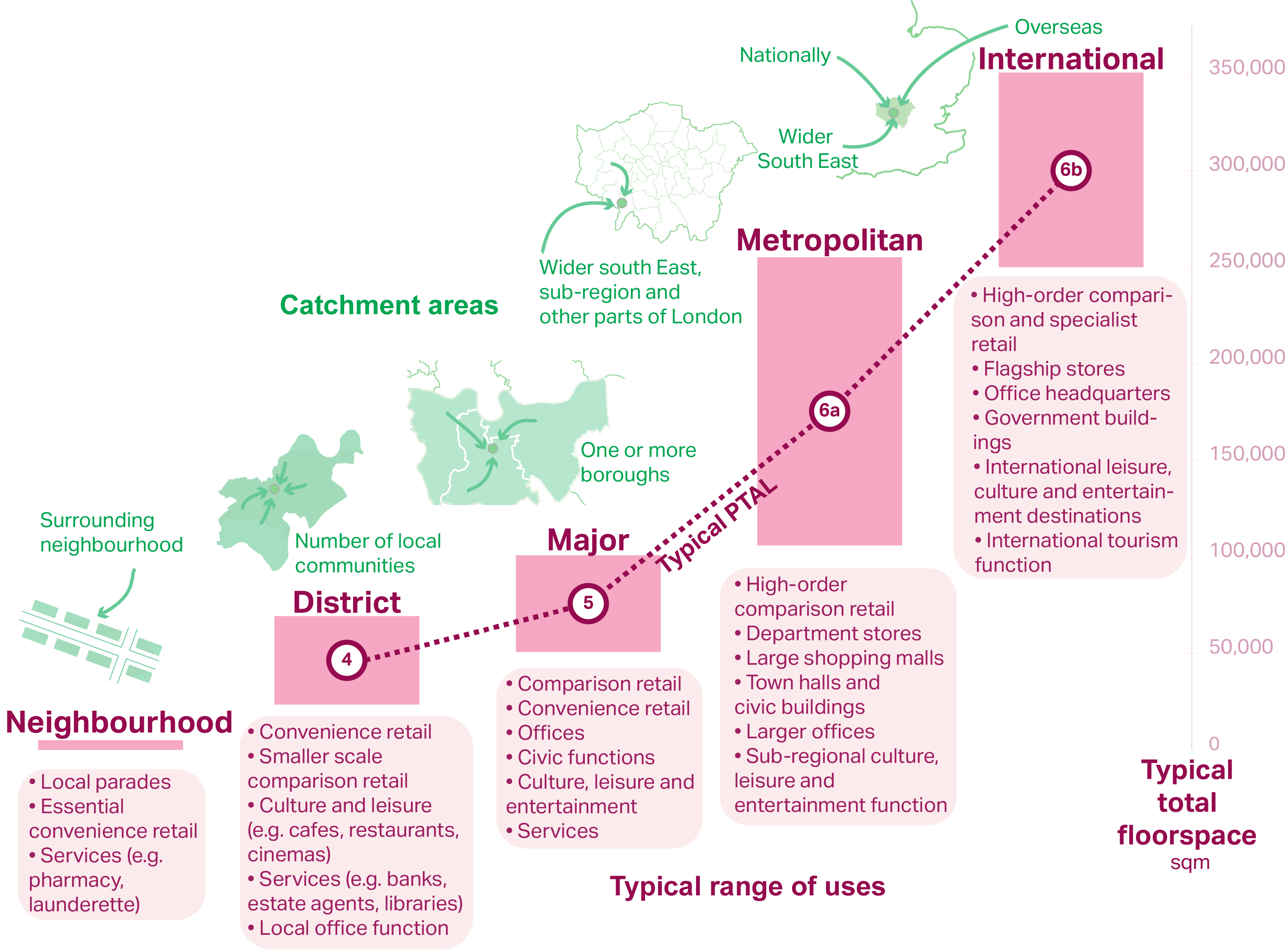
2.8.1 London’s town centre network is a vital element of London’s economy and is crucial for meeting the needs of Londoners and those who work in and visit London. It promotes a broad distribution of centres of different roles and sizes across the capital, complementing the role of the Central Activities Zone, allowing all parts of London to access a wide variety of services, and enabling and encouraging local economies to thrive. Figure 2.18 shows typical characteristics of town centres within each classification.
2.8.2 The town centre network is dynamic and allows the role and function of centres to change over time. The role of individual centres within the network will need to be proactively managed in order to ensure that the network as a whole continues to serve the needs of Londoners and London’s economy. In some instances, particularly within Opportunity Areas, it may be appropriate to designate new town centres to meet the needs of the local community and to serve areas of deficiency for certain uses. It may also be appropriate to re-classify some existing centres, in order to respond to shifts in demand for commercial uses or to reflect significant spatial, environmental and public transport connectivity improvements to existing out-of-centre retail parks.
2.8.3 Given the strategic importance of the larger town centres, changes to the classification of existing or proposed International, Metropolitan and Major centres must only be undertaken through the London Plan. Changes to the classification of District, Local and Neighbourhood centres can be brought forward in Local Plans. It is important that any changes or additions to the town centres network are supported by robust evidence, particularly looking at the wider impact on the network, informed by regular town centre health checks, and undertaken alongside reviews of town centre boundaries. To assist with this process, Table A1.1 in Annex 1 provides an indication of potential future changes to the town centre network over the Plan period, including new potential centres.
2.8.4 Centres with a future potential network classification in Table A1.1 (Town Centre Network) are not recommended for immediate reclassification, however it is recognised that they may be appropriate for future reclassification, subject to strategic and Local Plan policies and conditional on matters such as capacity analysis, impact assessments, land use, public transport, walking and cycling, planning approvals and full implementation. Many of the areas identified as future potential town centres, and centres with the potential to be reclassified at a higher level in the town centre hierarchy (see Annex 1), currently contain retail parks, dominated by large format stores and heavily reliant on travel by car. For these areas to be reclassified, a clear strategy should be developed and implemented (see Policy SD9 Town centres: Local partnerships and implementation) that secures a broader mix of store sizes and formats and a variety of town centre uses including retail, leisure, employment and social infrastructure, subject to demand, capacity and impact. The sizes and uses of premises should relate to the role of the future centre within the town centre hierarchy. Such areas also present significant opportunities to reduce reliance on car travel, create attractive and welcoming places that encourage and enable walking, cycling and the use of public transport, and facilitate new housing.
Policy SD9 Town centres: Local partnerships and implementation
2.9.1 Each town centre is unique. They have their own economic geographies, specialisms and character. They are changing in different ways and have different relationships with the residential and other areas around them. Some have more capacity and potential to grow than others. All town centres, however, will change – many of them significantly – due to the restructuring of the retail sector and other changes in the wider economy. A strategy should be developed for town centres that are experiencing significant change, such as projected declining demand, or significant planned infrastructure, or town centres that are identified as future potential centres in Table A1.1. This is necessary to ensure that the local community continues to be well served and that the network of town centres across London continues to function successfully.
2.9.2 Town Centre Strategies should be tailored to each town centre. A clear vision should be developed with the local community, taking account of the town centre’s strategic role, opportunities for growth, potential to support regeneration, spatial characteristics, economic challenges, and location in inner or outer London. Strategies should also consider the role of the night-time economy, as well as the cultural, heritage and tourism characteristics of the area. Town Centre Strategies should cover a broad remit, co-ordinating a tailored approach to planning, environmental health, licensing, Healthy Streets, transport strategy, highways management, logistics and servicing, regeneration, air quality, investment and projects. They should be developed with input from relevant stakeholders, including TfL, commercial landlords and investors, Business Improvement Districts and business associations, social infrastructure providers, Historic England, and community and amenity groups. Town Centre Strategies should pay particular regard to the social and economic benefits of high streets as well as their function and character within town centres, especially the formal and informal networks that support local communities. They should also have regard to commercial and social activity that serves particular groups and communities.
2.9.3 Boroughs should undertake town centre health checks regularly. This should be informed by the London-wide town centre health check[25] and should be tailored to local circumstances. Town centre health checks should take information from a variety of sources, including desk-based research as well as on-the-ground surveys, to establish the overall health of the town centre. This should include an analysis of the performance of commercial premises in the town centre as well as wider issues such as environmental quality and accessibility.
2.9.4 In many town centres in London, there is particular pressure on commercial floorspace to be converted to residential use. In order to ensure the vitality and vibrancy of town centres it is important that they contain an appropriate mix and quantity of office and other commercial floorspace, which can be supported through Article 4 Directions. Article 4 Directions can also be a useful tool for ensuring that development is undertaken in accordance with the Development Plan, particularly where comprehensive redevelopment is planned. In putting in place Article 4 Directions, boroughs should have regard to local evidence such as employment land and premises studies and the indicative categorisations for individual town centres set out in Annex 1.
2.9.5 The implementation of policy to diversify, intensify and realise the housing potential of town centres can be supported by a range of mechanisms for investment and ongoing management. Examples include Real Estate Investment Trusts, Local Asset-Backed Vehicles and Tax Increment Financing as well as specialist forms of housing investment such as Build to Rent, older people’s and student housing.
Policy SD10 Strategic and local regeneration
2.10.1 There are parts of London where the impacts of inequality and causes of deprivation are particularly concentrated. Based on the Index of Multiple Deprivation (IMD), many of the city’s neighbourhoods lie within the 20 per cent most deprived areas in England. These areas are defined in the London Plan as Strategic Areas for Regeneration. In addition, there are other parts of London where the impacts of inequality are acutely felt, which may not be fully reflected in the IMD; where relevant, these should be identified in Local Plans as Local Areas for Regeneration.
2.10.2 In order for regeneration initiatives to contribute to Good Growth it is important that they tackle poverty, disadvantage, inequality and the causes of deprivation, address social, economic and environmental barriers and benefit existing residents and businesses in an area. Regeneration can take many forms and involve changes of different scale and with different impacts, depending on the needs of local communities and the character of the area. Often regeneration will take the form of incremental improvements over a number of years, involving a range of projects and initiatives, such as providing affordable workspace, creating more accessible and welcoming public realm, or investing in training and employment opportunities for local residents. Where proposed, large-scale development in Areas for Regeneration should seek to reduce inequalities.
Figure 2.19 - Strategic Areas for Regeneration

Strategic Areas for Regeneration (based on 20 per cent most deprived lower super output areas in England)
2.10.3 All stakeholders, communities and individuals have a role to play in tackling poverty, disadvantage, inequality and the causes of deprivation, particularly in places where their impacts are acutely felt. There should be a focus on these areas in strategies, decisions, and bids for funding undertaken by the boroughs, the GLA family and other stakeholders to ensure these areas benefit from investment in strategic infrastructure, social infrastructure, and regeneration initiatives. In order to be effective in improving the lives of those most affected by inequality, regeneration initiatives must be undertaken in collaboration with local communities, involving a broad spectrum of groups, businesses and individuals, to develop a shared vision for the area. Successful regeneration requires all stakeholders to operate in a collaborative way, pooling resources and creating partnerships. There should be a shared understanding of how the regeneration area needs to change, and how that change will be secured, managed, embedded within and supported by the community. By taking an integrated, spatial approach to a wide range of issues, Development Plans and Opportunity Area Planning Frameworks have a key role to play in tackling inequalities and the causes of deprivation. It is important that these are developed through engagement with local communities.
2.10.4 In preparing plans, strategies and initiatives for the Strategic and Local Areas for Regeneration, boroughs should use their local knowledge and that of their communities to identify and understand the particular needs of these areas. The individual measures of deprivation that make up the IMD and other evidence, including baseline social, economic and environmental information should be used to inform the preparation and monitoring of Local Plans and regeneration strategies. Boroughs should identify Strategic and Local Areas for Regeneration in Local Plans and include policies that address the particular issues that affect them and the surrounding areas.
2.10.5 Many of the Opportunity Areas identified in the London Plan intersect with Areas for Regeneration. Where this is the case, Development Plans and Opportunity Area Planning Frameworks should identify the particular needs and character of the area, and identify how investment and development should tackle the specific causes of deprivation that impact on the lives of people in the area, while enriching the qualities of the area that make it unique.
2.10.6 The Areas for Regeneration are home to many established and varied communities, and there is likely to be a strong sense of place, local identity, and character that is reflected in the buildings, streets and spaces in the area, the lives of the people that live there and the activities that take place. Local Plans, Opportunity Area Planning Frameworks, and regeneration strategies should identify, protect and promote the places and spaces that are particularly valued by local communities and other stakeholders, including cultural venues, heritage assets, community facilities and social infrastructure, as well as creating new spaces for people to enjoy.
2.10.7 Annex 1 identifies the town centres that are within or intersect with Strategic Areas for Regeneration. Development Plans, Opportunity Area Planning Frameworks, and town centre and regeneration strategies should consider the needs of these town centres and others that are easily accessible from Areas for Regeneration, and set out how town centre renewal and investment will contribute to the regeneration of the area. Town centre strategies and Local Plans should address in detail the particular performance of town centres and their role in providing access to local services and employment opportunities for the Areas for Regeneration.
[6] http://www.london.gov.uk/about-us/organisations-we-work/policy-and-infrastructure-collaboration-across-wider-south-east
[7] NPPG – Paragraph: 007 ‘Duty to Cooperate’, DCLG, 6 March 2014
[8] Locally-led Garden Villages, Towns and Cities, DCLG, March 2016
[9] The term ‘satellite’ is used to indicate that the NIOD is geographically separate from the CAZ but it is treated as part of the CAZ in London Plan policy.
[10] These locations are not formally within the CAZ and are identified as future strategic reserves for nationally significant office functions in the event that future demand for office space exceeds development capacity in the CAZ. Specific policy directions for Stratford and Old Oak Common are contained within supporting text to Policy SD1 Opportunity Areas) and Annex 1 (Town Centre Network)
[11] London Office Policy Review, Ramidus Consulting, 2017
[12] Small Offices and Mixed Use Development in the CAZ, Ramidus Consulting, 2015
[13] Mayor’s Environment Strategy 2018
[14] Details on the TfL website: https://tfl.gov.uk/modes/driving/emissions-surcharge, https://tfl.gov.uk/modes/driving/ultra-low-emission-zone; See also the Mayor’s Environment Strategy 2018
[15] Consumer Expenditure and Comparison Goods Retail Floorspace Need in London, Experian, 2017
[16] The CAZ fringe refers to areas that have a functional relationship with the CAZ and lie within reasonable proximity to the CAZ but do not lie within the Zone itself
[17] London Industrial Land Supply and Economy Study, AECOM, 2016; London Industrial Land Demand Study, CAG Consultants, 2017
[18] London Office Policy Review, Ramidus Consulting, 2017
[19] London Office Policy Review, Ramidus Consulting, 2017; Small offices and mixed-use development in CAZ, Ramidus Consulting, 2015
[20] Policy SD6 Town centres and high streets applies to the entirety of Angel town centre and Elephant and Castle town centre.
[21] Consumer Expenditure and Comparison Goods Retail Floorspace Need in London, Experian, 2017
[22] Consumer Expenditure and Comparison Goods Retail Floorspace Need in London, Experian, 2017
[23] Policy SD7 Town centres: development principles and Development Plan Documents applies to the entirety of Angel town centre and Elephant and Castle town centre.