Key information
Publication type: General
Publication date:
Contents
6 sections
Overview
This report is a data visualisation output of the London Assembly Research Unit.
It provides an overview of London’s rivers and waterways, including their location, river health information, water safety data, and wildlife restoration projects.
It also includes information about swimming and water sports in and on London’s waterways, and use of the Thames for passenger and freight transport.
This page presents highlights from the report, with the full document available from the link below.
Blue space
Blue spaces are areas dominated by surface water bodies. Blue space makes up 2.9 per cent (4646 hectares) of total space in London.
The map below shows the proportion of blue space in each London borough.

Source: GLA, London Green and Blue Cover - London Datastore, Table: Green Cover Borough Summary, 2018
Open water swimming
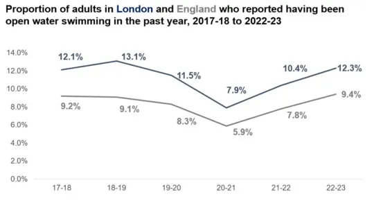
Active Lives Survey data shows the proportion of adults in London and across England who reported having been open water swimming in the past year.
Various locations are available across London for open water or outdoor swimming. This activity should only be undertaken in line with safety advice and never in locations where it is not allowed. Advice is is available from a number of organisations including the London Fire Brigade, Port of London Authority and The Rivers Trust.

Source: Sport England, Active Lives Survey, November 2022 to November 2022, via Active Lives Data Explorer tool
Cleanliness
Thames River Watch programme collects litter from eight sampling sites in London. In 2022, 2023 and 2024, wet wipes were the litter item collected most frequently. The chart below shows the prevalence of other litter items, with more information on sewage discharge also available in the full report.

Source: Thames River Watch Science programme, Monitoring Dashboard, accessed 5 December 2024. The following categories have been combined; plastic bottles with plastic bottle lids, tampons with tampon applicators, toilet fresheners with other sewage, agriculture with other plastic litter, and rubber, paper/card, metal and textiles were combined into other litter.
River freight
The Thames is an important route for freight transport in London. The chart below displays the amount of freight transported on the Thames over recent years.
The full report also includes data on use of the Thames for passenger transport.

Source: Department for Transport, Port and domestic waterborne freight statistics, December 2024 – Table PORT0704, ‘Major inland waterways routes, goods lifted’. Figures are rounded to the nearest 0.1 million tonnes.
Drownings and rescues
Rivers and waterways can be a high-risk environments, with emergency services often called to incidents where people are in distress in a river or waterway.
The chart below displays data on how many drowning or water rescue incidents were attended by the London Fire Brigade in recent years.

Source: London Fire Brigade, London Fire Brigade Incident Records, accessed 30 January 2025. Data was generated using the following filters, IncidentGroup: Special Service, SpecialServiceType; Rescue or Evacuation from Water and Suicide/Attempts, PropertyType: Lake/Pond/Reservoir and River/Canal.
Related documents
London's rivers and waterways